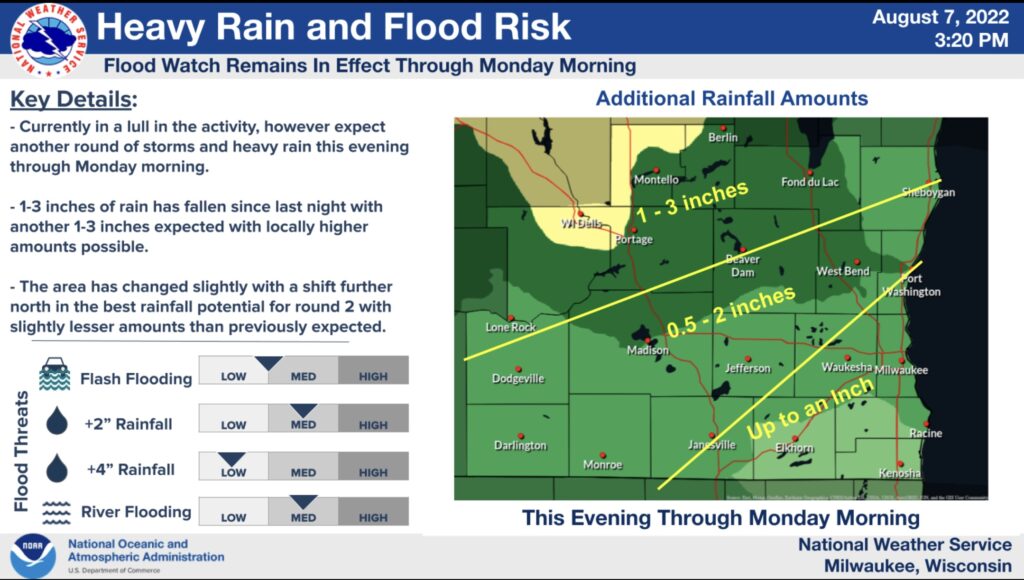


Update from National Weather Service 8/7 @ 3:24 p.m.:
– A Flood Watch for flash flooding remains in effect for all of southern Wisconsin through Monday afternoon.
– Outside of showers pushing through eastern Wisconsin we are in the lull in activity that should last through the early evening.
– The next round of rain should begin around mid evening bringing another round of 1-3 inches to the area it impacts with localized higher amounts possible.
– Uncertainty remains in exactly where this will occur but the flooding concern continues with any training storms. – Rainfall rates of 2-3 inches per hour are possible with storms.
What has changed? – The area has changed slightly with a shift further north in the best rainfall potential for round 2 with slightly lesser amounts than previously expected. Still some uncertainty on where we will see the highest rainfall totals with this second round.
(See map below.)
According to the National Weather Service Milwaukee/Sullivan Weather Forecast Office, A Flood Watch for flash flooding remains in effect for all of southern Wisconsin through Monday afternoon. An estimated 1-2 inches of rain had fallen by 5 a.m. on Sunday. A second round of rain will be late this evening into early Monday morning, bringing the potential for repeated rounds of heavy rainfall and flash flooding. Rainfall rates of 2-3 inches per hour are possible. Heavy rainfall over the same areas may result in flash flooding of low lying areas, urban areas, creeks and streams, and other vulnerable areas. Those in the Flood Watch area should prepare for the potential for flash flooding, and be prepared to seek higher ground if flash flooding occurs.