



By Dr. John Frye and Andrew Courtney to The Whitewater Banner
Dr. John Frye, Associate Professor of Geography with a focus in meteorology and climatology of extreme weather events at University of Wisconsin-Whitewater, storm chaser with 25 years of experience. Dr. Frye can be contacted at fryej@uww.edu.
Andrew Courtney holds a bachelor’s degree in Geography with a research focus in severe weather, storm chaser with 12 years of experience.
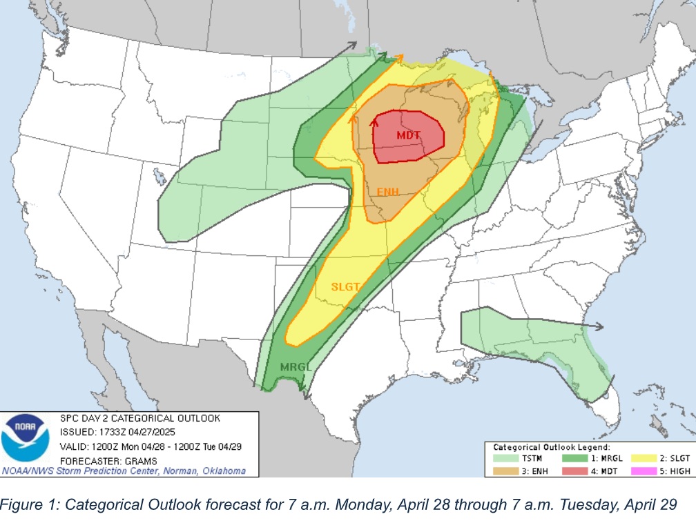
As of 3 pm Sunday, the Storm Prediction Center (SPC, www.spc.noaa.gov) has most of Wisconsin under an enhanced risk of severe weather from Monday 7 a.m. until Tuesday at 7 a.m. An enhanced risk is a level 3 out 5. A powerful storm system is moving across the country today and into our region tomorrow. This system is bringing together the ingredients to produce a wide-spread and powerful outbreak of severe weather.
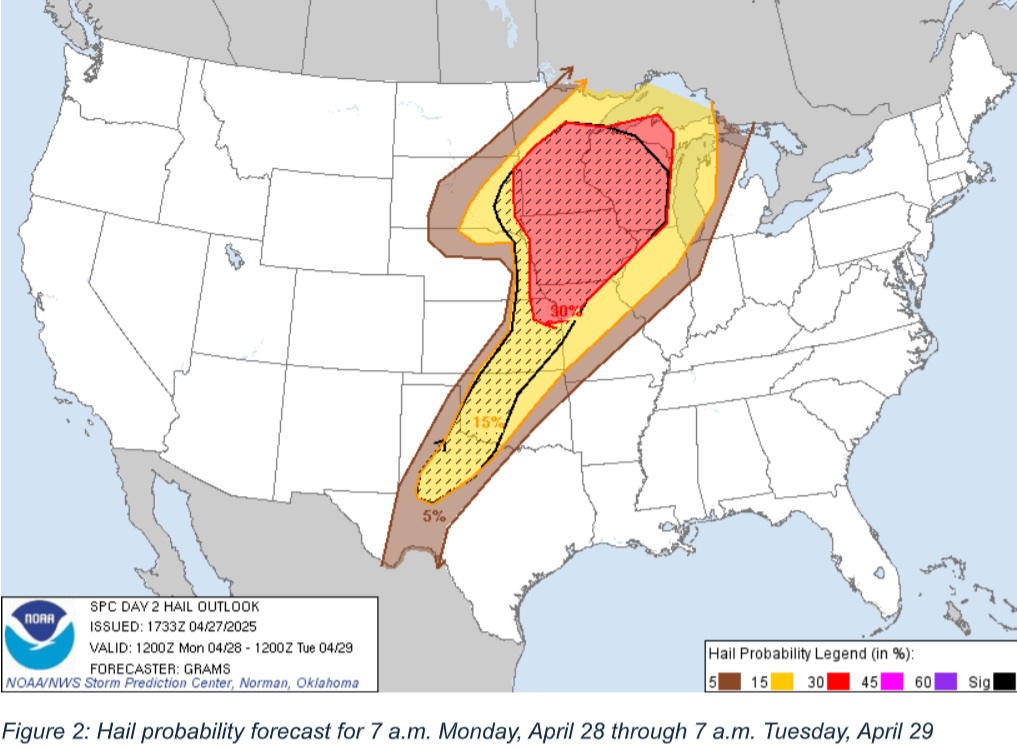
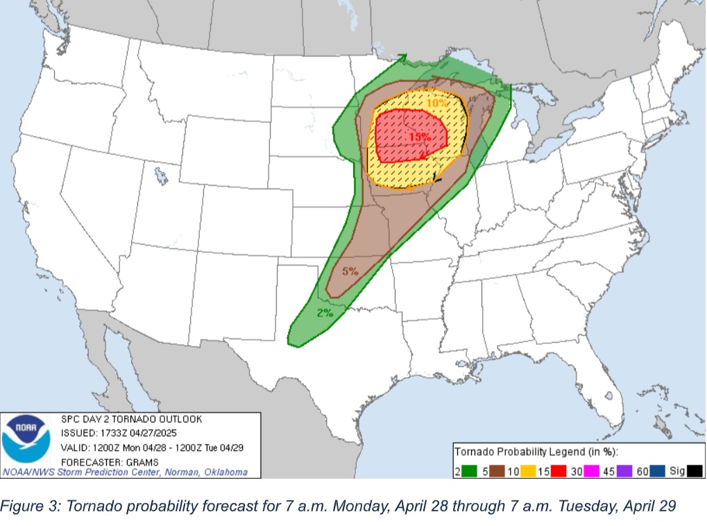
For Whitewater, the SPC has the greatest threat being hail and tornadoes. At this time, it is difficult to predict exactly where storm cells will form and track; that will become clearer as the event nears. Off to Whitewater’s northwest in western Wisconsin the threat level is a 4 out of 5.
The timing of this event looks to be after sunset tomorrow night for the eastern part of the state. Given the time and the increased threat, now is the time to start preparing for where you would shelter and how will you receive warning notifications in the case of a storm tracking near Whitewater. Here are some steps to help prepare yourself and your family:
Make sure everyone is aware of where you would shelter in the event of a tornado
Check back often on forecasts; as the event nears more precise information can be obtained. Follow the Storm Prediction Center and/or our Local National Weather Service out of Milwaukee/Sullivan on social media accounts.
o www.spc.noaa.gov
o https://www.facebook.com/NWSSPC
o https://www.weather.gov/mkx/
o https://www.facebook.com/NWSMilwaukee
Make sure to have multiple ways to receive a warning if issued by our local National Weather Service office.
Turn the Wireless Emergency Alerts feature to active on your cell phone
If you have a weather radio, make sure it is plugged in, tuned to the closest station to receive the best signal, and, if possible, put fresh batteries in it in case power goes out.
Download an alert app on your phone, like the Red Cross Emergency app. In this app you can turn on to have it track your position and you can also set a home location and boundary for that. This app is also useful if you have friends and/or family scattered around; you can track their locations too by adding more spots for the app to monitor.
An important reminder for Monday is the definitions of a watch and warning. A watch is usually issued before any storms start and it is telling us that the ingredients for severe weather or tornado, depending on the watch type, have come together in the
atmosphere and thus the event is likely. A warning means that a storm has begun and/or is showing on radar that it is producing wind, hail, or a tornado.
Figures below are the categorical and probability forecast from the Storm Prediction Center out of Norman, Oklahoma.
Editor’s note: The Banner appreciates Dr. John Frye and Andrew Courtney’s input regarding the incoming storm system.